Thursday, August 31, 2017

Southerndown to Gileston, August 30, 2017

6:30 taxi from Porthcawl to Southerndown where the mostly pleasant walk to Gileston began.  The first sight, a surprise, was a walled garden just off the path, but it was so cold, dark grey, and rainy that meandering through garden paths was not enticing, so after a peek inside, the sight remained unseen.

Doesn't this gate say "NYC subway?"


View after walking short, steep treacherous path:


Big field dotted with sheep:


You should know that walking through sheep fields is preferable to walking through cow fields.  There is less poop and the sheep do not stampede toward you.

 A pair of fog horns:


And a functioning lighthouse:


Now this tree limb overhanging the path did no harm because HAT was in backpack due to rain:


This sign was remarkable for existing, the signage today being, shall we say, scant.  But it is hardly inviting or encouraging:


Cliffs:


A fossil!


Enormous field of je ne sais pas..... (turnips?):


These corn plants: straight out of Pharaoh's dream:


It is not at all helpful when someone vandalizes signage:


After enough already of walking on these stones....


I espied this little sign (now righted) pushed into the bushes:


Despite the signage issues, arrived at the Hay Loft in Gileston, a most adorable cottage:


Up these stairs to the loft where the bed is:


Did not take long to get the laundry out to dry:


Was hoping to cook a nice little dinner in the cute little kitchen, but the local "store" had the most miserable selection of food.  It specializes in chips, soda, alcohol, and packaged sweets.  Still, it was nice to eat at a table, with food on a real plate, using proper cutlery.  Rhodri, the owner, said that tomorrow he would drop off a couple of eggs—he has chickens—so there will be an omelette for dinner!

Porthcawl to Southerndown, August 29, 2017

Today's walk was everything yesterday's wasn't:  short(ish), rainy, and beautiful.  It began in Southerndown, so another reverse walk like the one from Port Talbot to Swansea because of the same transportation situation.  

Southerndown is a friendly place:


where one feels safe:


and good company is to be had:


 A breach in the wall through which the company can run when you pass too close for their comfort:


But this little spotty-faced one was unusually unafraid:


Some quiet loveliness:


Just loved the name of this restaurant in Ogmore by the Sea (love that name, too):


Oh, how I wish I could watch this match!


Just after some woods, this sandy expanse appeared.  After trudging through it for a bit, consulted GyPSy, fortunately, and, whoa,  discovered I would have to find some other sand through which to trudge, as this was the wrong sand:


Awww...


Somebody's hard work of yesterday:


Sky and sand:


Sign to the right.....euphemism at its best


Wednesday, August 30, 2017

Port Talbot to Porthcawl, Monday August 28, 2017


There was a choice of routes today.  One could walk along back streets near this:


which the guide book strongly discouraged, or one could take the "high route," which the guide book strongly recommended, even though it was a mile and a half longer.  I cannot vouch for the difference in mileage, but the 15 mile day was more than 19 exhausting miles.

The start to the walk was in the same confusing place as yesterday's.  Behind the Civic Center in Port Talbot, where some combination of the A48, B4290, A483 and M4 converge in hideous roundabouts. There are Coast Path markers (not labeled, mind, just symbols like at Leila Day) for two routes toward Swansea and two routes toward Porthcawl, and aside from the web of roads, there are rivers that have to be crossed, highways that have to be walked under after another is traversed, and you, the walker, have to locate yourself in this confusion.  It took me about 15 minutes using the GPS to figure out how to approach the nice magenta track-line the device was displaying.  Such a good feeling when, at last, you figure it out.

Lots of climbing, lots of stairs, some mud, NO RAIN, you are on the way!  But you know that coming up is a wretched diversion due to a steel company's refusal to allow a short passage through their land.  "The walker is diverted, instead, to Pyle" (pronounced Pill) first forced again to deal with a horrible roundabout and then, once it is found, three miles along the A 48, a major highway. Since I have complained so much about the rain, this is a rare opportunity to complain about the sun and the heat. "Rescue me from this asphalt," you want to cry out as the cars whizz by making their loud
 V R O O M sounds one after an other after another.

At this gas station, you can wash your car, gas up, get your beverage of choice at a bargain price, and take off:


This is Mike who was right behind me in his very large tractory thing.  A mighty nice guy he was, too!  Soon our directions diverged.


It wasn't all highways and city streets.  There were dunes.  Have I complained yet about walking through sand?  Just in case I missed doing that, let me say that when you have on your heavy pair of boots as opposed to your Hokas, it is quite a lot of work. These dunes do not show the sand paths:


There were gorgeous beaches and estuaries as one neared Porthcawl:


A rare summer day in Wales during the 2017 season:


Tuesday, August 29, 2017

Mumbles to Port Talbot, Aug. 27, 2017

The itinerary is from Mumbles to Port Talbot, but I did the walk in reverse as it was easier to get to Port Talbot early in the morning than it would have been to get back to Mumbles in the afternoon because the bus that links these to towns does not run on Sunday, which day I happened to be walking.  Isn't that just the way things are!  

There were some climbs, some rural parts, and the long Swansea beach front, but for the most part, this was a ex-sub-urban-quasi-industrial route.  The worst feature of this geography is the roundabout.  Now, roundabouts are hellish anywhere, but some of the ones here are the BIGGEST I have ever seen, so when I had to navigate this particular one, I was so happy to see an overpass:


Only guess what?  It had as many exits as the road had directions.

Lots of the scenery was like this, only with more cars:


But there is a place for everybody:


And sometimes signs help you cross big roads:


Ads, just like on I 95 or the Post Road:


There was a not very pretty canal, along which the blackberries did not taste very good.  Thinking maybe a little pollution:


Swing bridge leading to Swansea:


There was a water park:


Approaching Mumbles, whom should I bump into but the one person I know in the entire town:  David, one of the owners of Langland Road B and B where I was staying.  He was on his way to the gym.  It was such fun to stop and chat for a couple of minutes.  Then, arrived in Mumbles, I washed my hair, which actually looked OK for about 20 minutes, changed into my "going out clothes," and headed straight for Joe's, the famed ice cream shop, where I had the best ice cream I ever tasted en ¡toda mi vida!

Penmaen to Mumbles, August 26, 2017

Today's drama began before I left.  All set to head out to catch the bus back to Penmaen whence to begin walking to Mumbles (isn't that the cutest name for a place?), I reached to open the exterior door to the B and B, the one I had been told was never locked, and, to my horror, saw that, not only was it locked, it had no handle.  It could only be opened with a key.  Having dutifully left my key in the room, I found myself in the little vestibule between two locked doors. (You can guess what I said to myself.)  What to do! I banged on the inner glass door.  I did this many times, and not timidly, may I add, not caring if I woke up the entire world.  Finally, the half-asleep owner appeared with a set of keys and let me out.  The nature of our conversation was idiotic, but the important thing here is that always wanting to leave more than enough time to get places and such, I did not miss the bus!

The bus stop is located next to a, yes, telephone booth, inside of which were these warnings:


So, good citizens put out their cigarettes on top of the trash can:


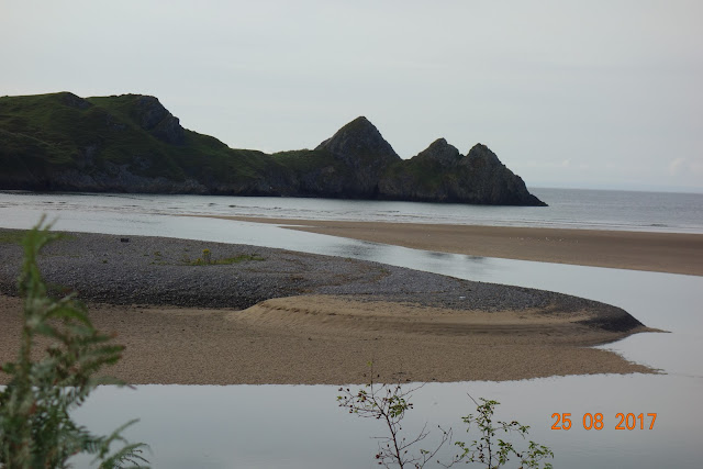
The walk started out beautifully, another day of stunning scenery and no rain.  I mean no rain in that it did not even threaten rain.  What a mechaiah!  Came to this gorgeous dune, estuary, cliff kind of area:


where, fortunately, heading in the opposite direction, the Clemments (sp.?) clan, as they referred to themselves, were crossing the river on submerged stepping stones.  Had they not been so doing, I would have had a) a hard time noticing these stones and b) if I had, would have wondered if it was dangerous to cross at such high tide.  The mom, familiar with the area, said that the water was just going to get higher, so, off came the boots and socks and onward I went.  It was quite refreshing, really, yet the current in the middle of the river had quite some pull, but off the stones I did not fall, and, relieved not to have slipped, reached the other side.  But let us cheer instead for that little girl! She did it without poles! (I have learned to much admire the scamperings of children!!)


When you are right near them, the stepping stones are obvious:


Then the GPS and the OS map clearly indicated that one was to ascend a S T E E P cliff and proceed around a peninsula.  The signage, however, pointed in quite another direction.  So dependent am I on my devices, that I tried the cliff, trudging up a very narrow path through very deep soft sand and then along a much too narrow cliff edge.  Scared, I thought, "I have done this before on the South West Coast Path, I can do it now."  Slowly I inched along the cliff until, just at the turn, there was NO PLACE to put your foot, and it was a sheer drop down.  If one could get around that turn, the rest would probably be OK, but this one could not and would not.  Honestly, I don't know if anyone could.  Back I centimetered my way along the cliff—it seemed to take forever—until, at the steep deep sand, I got on my hands and knees, and crawled backwards to safety, and obediently followed the signage, which pointed to a new, sane route, but not marked as such.  Harrowing is what this was and a waste of time!

I learned something today:  a shower cap is not a good wrapping for your snack of grapes. You can guess what I said to myself when the grapes hit the sand and dirt.

Oh, another thing I learned on this walk: If there is the slightest chance of rain, do not put your suitcase near an open window.

Things went well for a while until, taking a high tide diversion, I heard a thwack and found myself on my rear.  A low tree bough had knocked me to the ground.  Three thoughts about this:  in movies  of the goode olde dayes in Merrie Olde England, in which there is a plot to kill someone, just this sort of arrangement is contrived so that "someone" gets knocked off his horse, is stunned silly, and if things go as planned, dies.  The second was about my annoying HAT, which unlike lost HAT, has a too big floppy brim preventing proper vision at critical moments.  The third was whether I would be catapulted toward dementia or suffer loss of brain function.

Not that I am competitive or anything, but, passing a well-heeled pater familias, local to the area, who was walking with visitors, I asked him how long it would take to get to Mumbles.  "Oh, four or five hours," volunteered Gramps in a somewhat condescending way.  Three hours later I rang the bell to the B and B.

Professional photos of Worm's Head that really belong on a different post but due to Blogger's idiosyncrasies they are here!


Oh, sweet memories!


Definitely worth a trip!